Urban Heat Loss - Revealed

Urban Heat Loss - Revealed

Where is waste heat (red) leaving your home?

Overview

Welcome to the Geovation Group. We are an innovative and diverse group of geospatial scientists and researchers motivated to better quantify, visualize, understand and communicate the urban complexity of our planet.

Home

Research

Team

MyHEAT

Home

The Geovation Group was established in 2019, and builds on the legacy of the Foothills Facility for Remote Sensing, a co-directed lab that was created in 2005. This new group is directed by Dr Geoff Hay. We conduct operational and curiosity-driven research in urban remote sensing within the scientific frameworks of GIScience, Landscape Ecology, GEOBIA (Geographic Object-Based Image Analysis), Computer Vision and Machine Learning.

Mission

Our Mission is to provide a stimulating environment and exceptional resources in Remote Sensing and GIScience for the development of innovative geospatial solutions to pressing urban challenges, and for the training of a new generation of geospatial scientists.

Scientific Goal

Our scientific goal is to develop and operationally apply innovative theoretical and methodological approaches to better understand, map, monitor, model and communicate the multi-scale dynamics of urban ecosystem patterns and processes.

Generous support for this research has been provided by the following groups and organizations

Research

Dr Hay’s long-term research program is titled “The Remote Sensing of Urban Energy Efficiency.” It involves the use of high-resolution (25 cm-1m) Thermal Infrared (TIR) imagery, geographic object-based image analysis (GEOBIA), machine learning, GIS and geo-spatial analysis to accurately define urban energy efficiency from space.

Problem: The world wastes more energy than it uses – every year, with billions of gigajoules of wasted heat energy escaping from millions of buildings in thousands of cities worldwide [1]. Although energy-efficiency (EE) programs exist worldwide, most only measure energy consumption – not waste energy [2]. This is because waste-energy is invisible to the human eye, and challenging to quantify – and it’s difficult to measure, monitor, or manage something that we can’t see. Yet, waste-energy is responsible for an estimated 50% of urban energy demand, but is missing from urban energy efficiency equations. 

Solution: In order to solve these challenges, Dr Hay’s long-term goal is to evaluate whether high-resolution airborne thermal infrared (TIR) imagery acquired by the Canadian made TABI-1800 (Thermal Airborne Broadband Imager) can be used to quantify, map and monitor urban energy efficiency over time, at the resolution of individual houses, and the scale of a large Canadian city with over 1 million residents. 

Proposed Research Projects

This is an example of projects either underway, or potentially available for students to work on that involve high-resolution (25 cm-1m) TIR imagery, geographic object-based image analysis (GEOBIA), machine learning, GIS and geo-spatial analysis.

TIR Derived Urban Energy Efficiency

Potential PhD Project

The Role of Anisotropy on TIR Waste Heat

Potential PhD Project

Auto-Roof Extraction from TIR Imagery

Potential MSc Project

TIR Hot-Spot Stability over Time and Space

Potential MSc Project

Machine Learning to Generate 3D Results from 2D TIR Imagery

Potential MSc Project

Diagnostic Machine Learning of TIR Heat-Loss Patterns

Potential MSc Project

Thermal Hyper-spectral Assessment of Roof Materials with the TASI-600

Potential MSc Project

Defining Roof Materials with RGBi Imagery

Potential MGIS Project


Your
Research Project

References:[1] International Energy Agency. (2017). Energy Efficiency 2017. Retrieved from iea.org/ publications/ freepublications/ publication/ Energy_Efficiency_2017.pdf [2] Hemachandran B., et al., 2018. Chapter 11. Urban Remote Sensing 2nd edition. (Editor Q. Weng). Taylor and Francis Catalogue ISBN: 978-1-138-05460-8. pp 235 – 270.

Team

Meet our team

Our diverse team typically fluctuates between 2-10+ individuals, depending on where folks are in their program. Ideally, Dr Hay prefers a research team of 3-5, allowing for meaningful research, teaching and leadership opportunities through team participation and collaboration.

Since 2005, Dr Hay has been engaged in the training of 32 Highly Qualified Personnel (HQP) including: (3) Post Doctoral Fellows, (3) Research Associates, (6) PhD’s, (5) MSc’s, (13) MGIS and (2) Co-supervised students. Several of whom, have gone on to be hired by Dr Hay’s University startup, which has been in business since 2014. Others have gone on to numerous Geospatial positions in Government and Industry, with the first graduate student now an Associate Professor developing his own research program.

To view a list of HPQ alumni and their research contributions, please click here.

Dr Geoff Hay

Director

Dr. Geoffrey J. Hay is an Associate Professor in GIScience at the University of Calgary, Director of the Geovation Group and Co-Founder and Chief Science Officer at MyHEAT. Inc.

Salar Ghaffarian

MSc Student

Salar Ghaffarian has a master’s degree in Geomatics Engineering and specializes in Remote Sensing Science. He is using machine -learning and high-res’ thermal imagery to automatically map residential rooftops.

Corey Hughes

MGIS Student

Corey Hughes has a bachelor’s degree in Urban Studies and Geography from the University of Calgary and is in the UC MGIS program. He specializes in GIS.

New (2020) $30K /4yr PhD Scholarship in Urban Remote Sensing

Deadline: This September 2020 scholarship opportunity closes January 15, 2020 (or when filled).

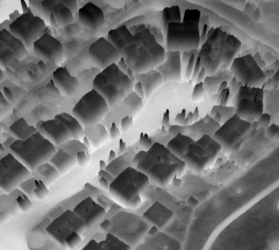
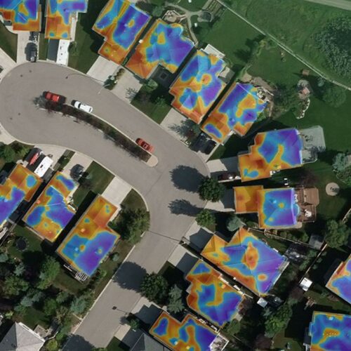
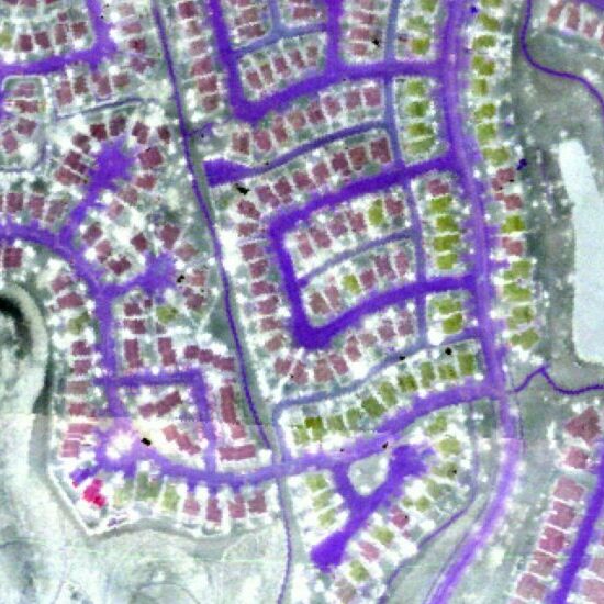
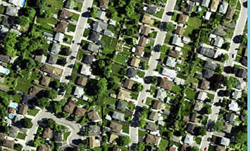
Applicants are invited to apply for a University of Calgary Eyes High PhD Graduate Research Scholarship (open to all nationalities) in Urban Remote Sensing with an emphasis on Geographic Object Based Image Analysis (GEOBIA), Machine Learning and H-Res’ Airborne Thermal Imaging.

This award is for $30,000 (CDN) per year for 4 years at the PhD level in the Department of Geography. It will be carried out as a member of the Geovation Group under the supervision of Dr. Geoffrey J. Hay

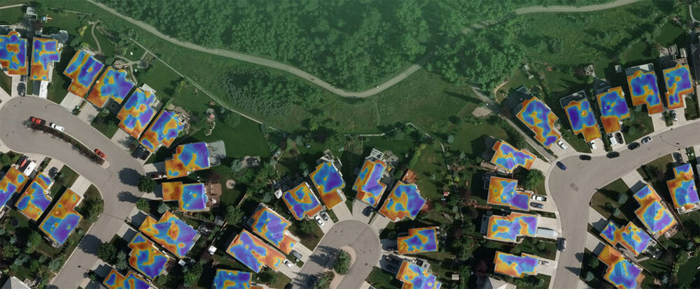
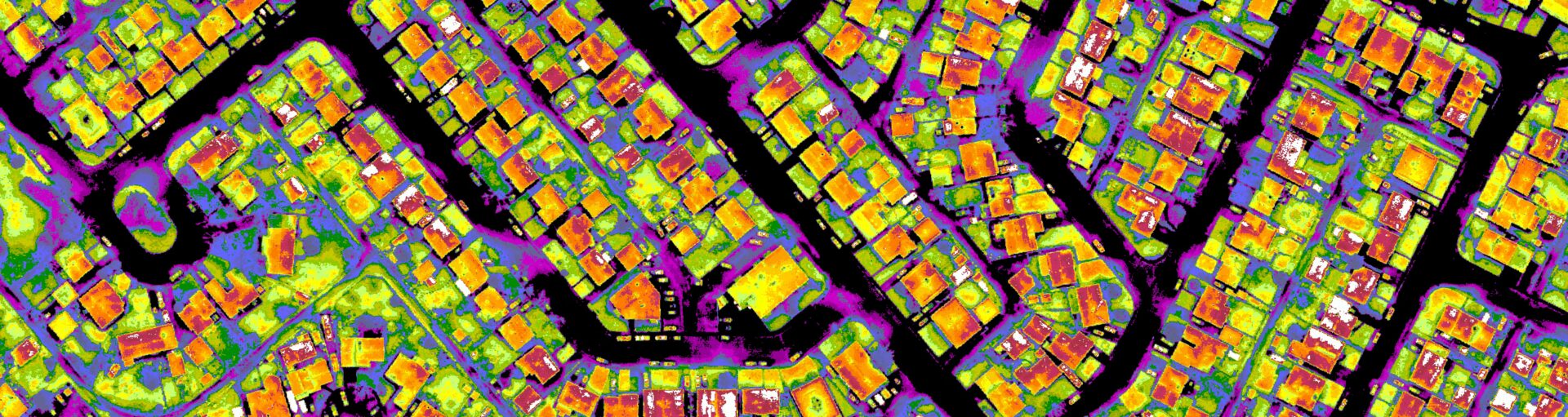
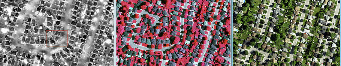
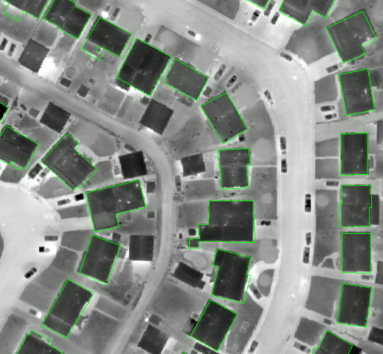
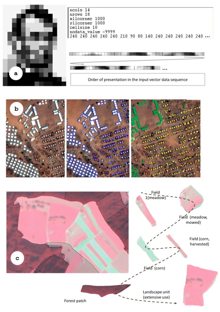
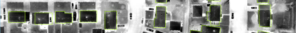
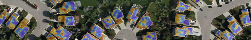
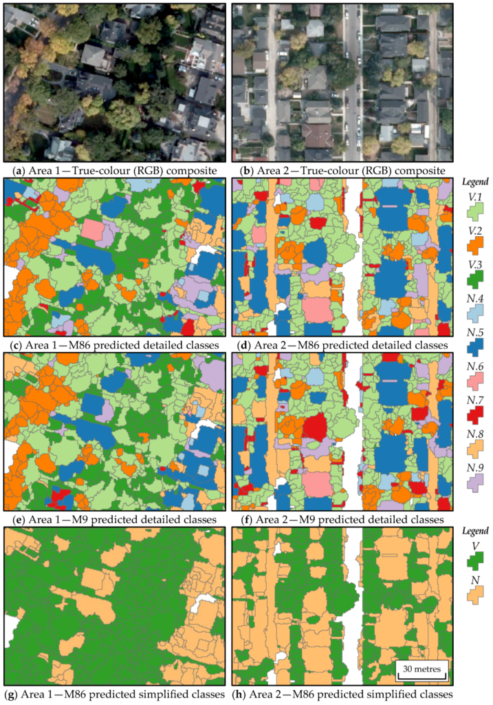
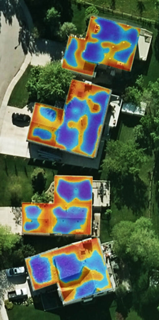
Preference will be given to those with a strong background in digital urban remote sensing (ENVI & IDL), GEOBIA (ENVI-FX, eCognition), GIS (ESRI, QGIS), spatial statistics (R, SPSS, S-Plus), Machine Learning(pytorch, tensorflow, keras, etc), computer programming (IDL, Matlab and Python) and web-development, as well as strong oral and written English language abilities. The ability to communicate and publicly present well in social settings, and conduct research both on their own, and as part of a team are desirable assets. Ideally, candidates will have interest/expertise in: (i) Segmentation of dense urban roof tops/buildings, roads and vegetation from high-resolution TIR/RGBi imagery, (ii) Generation of heat-loss and energy-efficiency metrics from high-resolution TIR imagery.

The successful candidate will have access to state-of-the-art department computing, software and digital library resources as well as high-resolution thermal and RGBi urban remote sensing and GIS datasets. Opportunities may also be developed for motivated students to collaborate with Industry partners.

Academic Requirement: (i)Applicants must hold a minimum grade equivalent to a GPA of 3.5 on a 4.0 scale OR an (A-) to (A+) average. If your degreeis not from a Canadian institution, please check the Faculty of Graduate Studies website for information on International requirements for admission. (ii) For those whose first language is not English, we require either TOEFL or IELTS. In general, the minimumis an overall IELTS score of 6.5 and no band less than 6.0, and/or TOEFL of 86 with no section less than 20 (internet based).

Supporting documents: Please email Dr Hay with (i) copies of academic transcripts, (ii) a curriculum vitae, (iii) a brief project proposal/statement (one-page max) of how your research may fit Dr Hay’s, (iv) copies of your TOEFL/IELTS results, and (v) a list of at least three references that Dr. Hay can contact. Please ensure that your CV includes a list of all awards/scholarships/grants, presentations, and related publications, as well as areas of expertise, training and knowledge, and other relevant experiences. International students must provide transcripts in their original language as well as an English translation. 

Please email supporting documents as a complete package (not compressed) to gjhay@ucalgary.ca and include Subject Heading “Eyes-High PhD Scholarship Application”.

New GEOBIA Review Publication

In October, 2019 Dr Hay co-authored an important GEOBIA review paper in the ISPRS International Journal of Geo -Information (IJGI) titled GEOBIA Achievements and Spatial Opportunities in the Era of Big Earth Observation Data”.

The objective of this paper is to review the role of spatial concepts in the understanding of image objects as the primary analytical units in semantic EO (Earth Observation) image analysis, and to identify opportunities where GEOBIA may support multi-source remote sensing analysis in the era of big EO data analytics. It also (re-) emphasizes the spatial paradigm as a key requisite for an image understanding system able to deal with and exploit the massive data streams we are currently facing.


Salar Ghaffarian successfully defends MSc Thesis Proposal

On Sept 11, 2019, Salar Ghaffarian successfully defended his thesis proposal. Salar’s proposal was titled “Automatic Mapping of Residential Rooftops using High-Resolution Thermal Imagery”. In order to meet the needs of our commercial partner (MyHEAT) this research proposes two main goals: (1) optimize a leading-edge Convolutional Neural Network (CNN) method for automatic and accurate rooftop delineation from MyHEAT’s existing H-Res TIR imagery and (2) define the optimal spatial resolution for CNN based rooftop delineation. By satisfying these goals, we expect to: (i) reduce MyHEAT’s ancillary data acquisition/processing costs as their (optimal resolution) TIR imagery will be the only required data source for HEAT loss metrics, (ii) speed up their entire analytical pipe-line, as there will be no need to acquire, correct, or negotiate for auxiliary data, (iii) be able to apply the optimized model to existing and future archives of MyHEAT TIR imagery.

All committee members noted how well written the proposal was. Well done Salar.

Dr Hay receives a 5yr NSERC grant

In April 2019, Dr Hay was awarded a 5 year NSERC Discovery Grant (2019-2023) for his newly proposed research program titled “The Remote Sensing of Urban Energy Efficiency”. His long-term goal is to evaluate whether high-resolution airborne thermal infrared (TIR) imagery acquired by the Canadian made TABI-1800 (Thermal Airborne Broadband Imager) can be used to quantify, map and monitor urban energy efficiency over time, at the resolution of individual houses, and the scale of a large Canadian city with over 1 million residents. 

This has never been done before with remote sensing imagery.

Dave Griffith publishes MGIS research

In November 2018, David Griffith (MGIS, 2018)  published his MGIS project in the ISPRS International Journal of Geo -Information* – titled: “Integrating GEOBIA, Machine Learning, and Volunteered Geographic Information to Map Vegetation over Rooftops. It was also selected as the Cover Paper for the GEOBIA 2018 Special issue (GEOBIA in a Changing World).  

The objective of this study is to evaluate operational methods for creating a particular type of urban vegetation map – one focused on vegetation over rooftops (VOR) -specifically trees that extend over urban residential buildings.

Since this time, David has accepted a full-time position at MyHEAT, as an Applied Scientist specializing in Remote Sensing and Machine Learning. Great Work Dave!

MyHEAT

Rooftop waste heat mapped from red-hot, to blue-cool.

Our University Startup Company

In Nov 2013, Dr Hay’s HEAT research team won the MIT Climate CoLab Grand Prize from over 400 crowd sourced contestants world-wide, and appeared in 25+ national/international media interviews. In April 2014, this research was commercialized as MyHEAT Inc.

MyHEAT is a Calgary geomatics startup company built on research developed by Dr Hay’s UofC research team. Since creation, MyHEAT has hired 4 University of Calgary graduate students/Postdocs from the departments of Geography and Geomatics engineering – including several of Dr Hay’s former students.

MyHEAT’s goal is to empower the Urban Energy Efficiency movement with a platform designed to help residents visualize, the amount of invisible waste heat (thermal energy) and associated GHGs leaving their homes, communities and cities, as simply as clicking on an image in Google Maps. In Jan 2016, the MyHEAT team unveiled their first commercial product as www.myheat.ca. In Sept 2016, they completed 500,000+ detailed heat-loss images at the house, community and city level for 5 Alberta Municipalities. By the end of 2017 MyHEAT had web-enabled over 1.3 million detailed images of Canadian buildings’ heat-loss (5.3M residents) in 21 cities and towns. By the end of 2019 MyHEAT had collected and processed proprietary thermal images for 47+ cities, in 2 countries (Canada and the United States), covering 11,000+ sq.km and a population of about 9 million people – with more projects planned in Canada, the United States and Europe.

For additional details please see this story